The overuse of cityscapes, London buses and New York taxis in photography has made it hard to find any remotely original pictures with which to adorn your walls nowadays. Which is a shame as the pictures we choose to hang on our walls can be a great way to relive past holidays and remember our favourite cities. My chosen alternative is to produce my own vintage map prints of my favourite cities I’ve visited which not only look great with their distinctive antique off-colour style but also allow you to trace your way back to that little street corner where you once sat and had a coffee, which was just as it was 200 years ago.
Finding Your Maps
 The real key to producing your own great looking vintage maps is finding high resolution images to work with, and I mean seriously big files. Ideally you’ll want an image file more than 2000 pixels across if you’re hoping to print anything larger than A4 but the best way to judge this is to look at the DPI (dots per inch) you’re map will be printed at. While a lot of people would prescribe no less than a 300 DPI print, others says that anything above 150 DPI looks identical to the naked eye and so essentially these matters vary depending on your hardware and personal preference. Either way though, you’ll need large image files which aren’t so easy to find.
A little-known recently added feature of Google Images search is the ability to filter results based on image size by clicking ‘Search tools’ > ‘Size’ but the best way to find antique map scans is through designated library sites. A great resource is OldMapsOnline.org which lets you filter by date and features a map of the world you can navigate. A range of maps relating to the area in your screen appear on the side panel which you can view and zoom in on but they don’t allow you to download the image files which is a real shame.
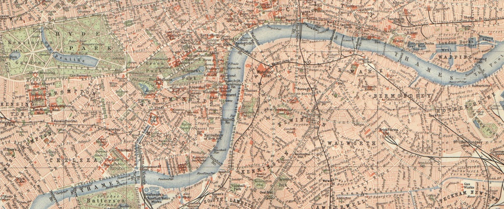
The best source I’ve found for antique map scans is the US Library of Congress Map Collection although their website is very dated and somewhat difficult to navigate. However with such basic Web 1.0 sites, there are no complex viewing interfaces and you’re free to download the source image files direct such as this 1860 map of London.
Printing Your Maps
When it comes to printing your maps, I’d seriously recommend using some specialist paper for a high quality vintage map print. This doesn’t need to cost the earth though and I recommend Black Diamond’s 220gsm matt canvas textured paper which as you might have guessed has a subtle raised canvas texture that gives your prints a really authentic antique look. A pack of 20 sheets will set you back about £7 on Amazon and is well worth it as the paper soaks up the ink better and gives a really professional looking finished print. You’ll find loads of other uses for it too so don’t despair about having to get 20 sheets. It’s also obviously great if you want to do a series of vintage map prints around your home.
If you don’t have an A3 printer then don’t worry. Despite most households now having their own printers, there are still printing shops on most high streets that can print your files for you for just a couple of pound. Some will even let you bring your own paper but don’t expect them to be able to offer this option. The only down side is that most commercial printers now use laser-jet machines as they are much faster and cheaper to run which tend to give a slightly glossy look to your prints.
Framing Your Maps
As for frames, this obviously comes down to personal preference. A highly detailed and ornate frame might work well if you’re trying to replicate an authentic antique map but these can easily end up looking tacky and so I tend to go for modern, clean-lined frames that put all the focus on the content. I’d definitely recommend sticking with the same frame style if you’re hoping to create more than one vintage map print so you’ll need frames that are both affordable and readily available. Who other to turn to than Ikea? The Ribba range makes framing your prints really easy as they come ready fitted with commonly sized passepartout mounts and are really cheap with their frame to fit A4 prints costing just £6 and the A3-ish option at £7. However note that their pre-cut mounts don’t fit A3 and above perfectly becoming squarer as they get larger so you’ll need to carefully select your maps or be prepared to crop white-space if you want to use their passepartout mounts.
Share this Post


